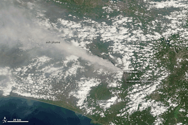
SESDA II staff help with the studies of sulfur dioxide and ash from Mount Merapi, Java, Indonesia
December 10, 2010
 SESDA II staff working at the GES DISC have developed a visualization tool named Giovanni (GES DISC Interactive Online Visualization ANd aNalysis Infrastructure). Giovanni provides data from several NASA satellites that allow monitoring of the atmospheric effects of the Merapi eruption. The Ozone Monitoring Instrument Level 2 Gridded (OMIL2G) interface provides daily SO2 data, which show the movement of the SO2 aerosol cloud over the eastern Indian Ocean during the series of eruptions occurring between November 5 and November 12. The threat posed by clouds of sulfur dioxide (SO2) and ash erupted into the firmament from Merapi caused the cancellation of airplane flights during some days of the eruption, and even affected the travel itinerary of U.S. President Barack Obama during his state visit to Indonesia.
The ongoing eruption of Mount Merapi on the Indonesian island of Java disrupted the lives of thousands of local residents, who live in the shadow of this active volcano, partly due to the agricultural richness created by the fertile volcanic soils on its slopes. Pyroclastic flows and ash deposition from a series of strong explosion events have caused hundreds of fatalities and required the evacuation of the local region. Despite the continuing danger from the volcano, some residents are trying to move back to their damaged homes already.
The Moderate Resolution Imaging Spectroradiometer (MODIS) instrument acquired the true-color image below, showing the erupting ash plume from Mount Merapi on November 10, 2010. (Image and labeling courtesy of the NASA Earth Observatory.
Comments are closed.
-
Article Details:
Posted on: Friday, December 10th, 2010
Posted in: SESDA News
Subscribe: RSS 2.0
Comments: No Responses -
Recent News:
