SESDA II staff add false color functionality to the Hurricane Data Portal
June 2, 2009
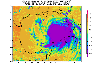
The GES DISC Hurricane Data Analysis Tool has added the capability to animate false color images of Merged Infra-Red (IR) data in addition to the previously available grayscale images. This capability enhances the images and animations that can be created with the Merged IR data from geostationary outlook satellites. After selecting False Color, the geographical area, time increment, and temporal criteria can then be entered. The image can be generated as an Animated GIF image.
The Goddard Hurricane Data Portal provides scientists and researchers the
ability to quickly investigate key parameters for tropical cyclones, hurricanes and typhoons around the world prior to selecting and downloading the full data set of interest. With only a web browser and few mouse clicks, users can produce visualizations for 8 years and over 4.5 TB of archived Merged IR Brightness Temperature data and generate false color, black and white IR imagery or animation without downloading any software and data. More information is available in the Hurricane Data Analysis Tool FAQ.
This image shows an animation of Hurricane Katrina generated with the False Color option in the Hurricane Data Analysis Tool. Note that this
animation was generated with the Pre-Defined palette; Dynamic and Custom palettes can also be used.
Comments are closed.
-
Article Details:
Posted on: Tuesday, June 2nd, 2009
Posted in: SESDA News
Subscribe: RSS 2.0
Comments: No Responses -
Recent News:

